Currently 1 visitor is viewing this site.
go back 1 of 2

Overview


Radiomap is an easy to use (computer) application to listen to live radio stations worldwide through the Internet. It comes in basically two flavours: As a single-user screen-based version and as a multiuser environment.

The user selects the radiostations from a photorealistic map of the world. These stations are selected with the help of crosshairs visualising Latitude & Longitude. A context-sensitive menu allows to change settings as genre and language of broadcasts. This results in powerful filtering abilities for individuals.
On the other hand the person experiences the application as being of very low complexity and intuitive to use.

All necessary data are accessed via a web-based database every time the application is started. This has the advantage that the application only has to be installed once onto the computer.

The multiuser environment works very similar but with different preferences: The crosshairs are replaced by a ring element that enables participants to connect to stations, there are no click-events only proximities - and there are no menus.

This concept-paper describes the basic structure of the application, the different interaction possibilities and sketches the dimension of the server-sided, database backend, the video-tracking application and the Editing-frontend for the database.

important

graphics are functional sketches!
No layout, no design!

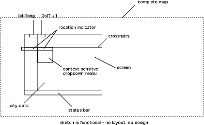
Structure & explanation of graphical elements


Element Lat/Lon

Depticts dynamically Latitude and Longitude of the place the crosshairs intersect. It highlights on mouse-down or if a station is shown the name of the city in the city-display.

! „70 N, 170 E” N eg. S can only reach „90” Degrees reichen, E eg. W reaches 180 Degrees.
Element GMT


Is only visible at mouse-down. Timezones display is not dynamic, not accurate but just blended over as GMT +1 eg. GMT –1 not in dependance to the Zero-Meridian. No DST. One hours steps – not 30 min (Iran, etc.)

! Typface clear and legible, favorably Geneva 9pt.


Element location indicator

Here name, city and country of a station are indicated.
Should the city have more than one station these are shown in a dropdown menu. The „last listened“ should be listed on top. The dropdown following below.

Complete map

The image-map as a whole is bigger then the screen-section.
It consists of two images render from the fourmilab.ch website. Each half is 960x960 pixel big.
It is desirable to have TWO images beside each other to enable an acurate, undivided view of the pasific region. This would also be beneficial for visualising traceroutes. The whole images measures then 4 x 960 pixels = 3840 x 960.

Current images are created by the application „xPlanet“ in five minute intervals and available at http://hohlwelt.com/radiomap/west.jpg eg. east.jpg.
East and West are oriented along the GMT Zero-Meridian, Greewich, London.

Traceroutes

A traceroute shows the route the IP packets take over the internet – a fundamental difference to the way radio signals are transmitted via the „ether.“ It is interesting to make this hidden property transparent for participants. The IP-addresses are resolved by the local-host and passed on to CAIDA where the Lat/Lon to IP mapping is resolved and sent back.

This function is demonstrated well in the application „WhatRoute”. Yet Splines are preferred to vectors!

Element crosshairs

The only real interaction-element in the interface. With it the stations lists can be accessed (rollover-dropdown), settings or preferences changed eg. the content-filtering adjusted.
The reverse motion of the background image is also attached to its movement (x-screen size). Click into „nothing“ opens a different menu then a click onto a city.

Element „drop-down” Menu

Rollover at a city (= at least one station) the available stations (genre/language filter!) are displayed followed by the menu items.
Rollover at mousedown(stilldown) into „Nothing” (e.g. ocean) opens the menu-items without stations.

Element status bar

The status bar is permanently displayed and communicates ongoing processes (e.g.: „loading“, „buffering“). It displays the currently playing station and all external player states as "establishing connection" e.g.. It provides necessary feedback and transparency for the participant. Indicating: „something is going on and i am not waiting in vain.“ In case of several, different messages at the same time, the statusbar should blink and toggle between the different messages. (e.g. „loading background image“, „establishing connection.“

City dots

Cities are NOT indicated by a permanent visual „one-pixel“ image. But upon mousedown they should highlight. Cities should be „magnetic“ to the crosshairs.

Dropdown menu & status bar


Interaction- und feedback procedures create the elegance and usability of the application. The opening of menus and selection of stations should happen „fluently“ instead of apruptly. It is elementary that actions in the field station-select and in the status-bar inform about reasons of performance problems (new bg image). Dropdown in nothing should highlight all possible stations / cities, preferably with a shape that is located at the actual place.

dropdown

there is only one kind of dropdown. It happens either upon ROLLOVER at a station/city – or upon MOUSEDOWN in „nothing“ (not a station/city). The difference is in the details important for terminal or environment version.
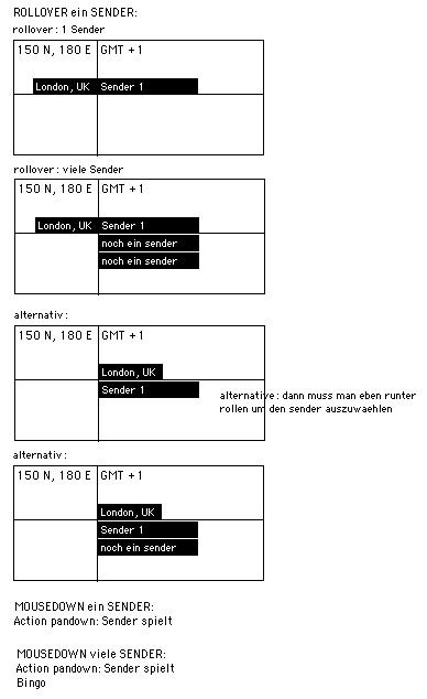
Allying should be a dropdown matrix for the different stages as shockwave, standalone, not environment, kiosk terminal.

dropdown station:

+ List of (visible) stations with selected filter: "<news, jazz>" stations in <London, UK>"
+ bookmark playing (only when playing)
+ bookmarks
+ Open <sendername> in browser
+ Show history Nonsense
+ shrink to desktop
+ volume OFF/ON
+ quit

dropdown Nothing:

+ bookmark playing (only when active)
+ bookmarks (folder hierarchy)
+ language
+ genre
+ show history
+ shrink to desktop
+ quit

categories are created with admin-tool or website.

genres

genres = ["Blues", "Classic Rock", "Country", "Dance", "Disco", "Funk", etc.]

<form action="/directory">
<b>List by Genre:</b><br>
<SELECT name="genre" onChange="top.location.href='/directory?genre=' + this.options[selectedIndex].value;" class="SelectBox"> <OPTION VALUE="TopTen" selected>-- Choose a genre --
<OPTION VALUE="TopTen">-=[Top 25 Streams]=-
<OPTION VALUE="Alternative">Alternative
<OPTION VALUE="College"> - College
<OPTION VALUE="Industrial"> - Industrial
<OPTION VALUE="Hardcore/Punk"> - Hardcore/Punk
<OPTION VALUE="Ska"> - Ska
<OPTION VALUE="Americana">Americana
etc.

Kiosk/Terminal Version


+ Single user
+ One station per city
+ Rollover only
+ Crosshairs
+ No menus, no prefs

the general difference is that there are NO dropdown menus and the only interaction is ROLLOVER – no mousedown. Cursor is indicated by crosshairs. As the crosshairs snap to a city the only (first from list) station begins playing. A station keeps playing until next station starts playing. Status bar, Lat / Lon as before.

Environment Version


+ Multiple users
+ Floor projection
+ Whole map visible
+ Shared Ring element – no crosshairs
+ Lively, animated „feel“ of interaction elements

The environment version is functioning similar to the kiosk/terminal but has a few fundamental differences: The WHOLE map is visible – not only parts of it. The map is projected onto the FLOOR. MULTIPLE participants that physically move upon the map trigger the radio stations. Still there only can play one radio station at a time. All aditional augmented information Lat/Lon, GMT etc. is missing.

The crosshairs are replaced by a 'ring" element which is shared among several participants. This connection / control is indicated by a line which protrudes from the persons position, connecting her with the circle element (Point of interest or PoI). The „tension“ applied to the PoI via the lines is divided, the PoI placed in the „middle“ – thus encouraging colaboration.

Environment with one visitor

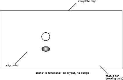
Environment with two visitors
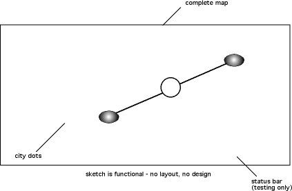
ring element /Point-of-Interest

the PoI replaces the crosshairs and is used to select radio stations.

The centre point of the PoI is the reference point. It can be used by one or more participants and has certain behaviours:

opacity

Its opacity changes dynamically upon proximity to a station moving dynamically from a low „breathing“ frequency, over a „nervous“ blinking to a final „permanent“ once it „snapped“ to a station.

Colour (status bar)

Once „snapped“ to a station the different states of the connection or download process that formerly were indicated by the status bar are indicated by colour changes. There are four states to be indicated: connecting, buffering, playing, error

Size

No changes in size at this time.

Behaviour / „feel“

Much of the experiential quality, e.g. „feeling of control“, „real time feedback“, transparency, charm and usability of the application relies on the behaviours of the ring-element, how it adapts to motion and reacts to people. Intuitive use is of major interest.

It should provide a viscosity in its movement, a certain animistic „aliveness“ in its reaction and inertia communicating weight. E.g. it should „avoid“ direct contact to people where possible. Also forgiveness / robustness concerning unintentional motion input is of interest.

Location indicator

No visible text - spoken by the system voice, preferably „Victoria“ or equivalent.

Radio stations

Only one station can play at any given time. This should be pre-selectable by the web- or admin-tool.

Drop-down menus

None of the functions are relevant here and should be ignored.

Genres

Not relevant in environment version.

Languages

Not relevant in environment version.

Demo-mode

It should allow a demo-mode for testing or debugging purposes that shows positions of people to adjust sensitivity of tracker and incoming participant data.
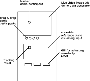
That allows to interact with the ring element via mouse and participants. Among others.
It should also be possible to exclude stream formats.

Tracker


The Tracker recognises participants on the map and sends their location to the radiomap application. Because of performance reasons it should run on a different computer. The preferable technology would be video-tracking and the platform Macromedia Director together with the „track-them-colors“ xtra.

From these affordances Stephan developed the Tracker: This is the documentation of his work.

Also the interface of TTC does not provide a GUI, the technology of identifying „blobs“ is fairly well developed and robust. Other systems should be taken into acount as well.
EyesWeb, softvns, WebCamXtra, BigEye

In case of a larger environment it should be able to attach multiple Trackers.

User-Interface

The tracker should be a standalone application that recognises if a camera is connected to the computer.

The current video image should be seen beside the reference area.

It should be possible to adjust the angle, dimension and location of the reference plane, the „sensitive“ tracking area.

There should be buttons for all necessary functions as: de-& increase sensitiviy, create reference frame, etc.

Demo mode

It case no camera is available there should be a demo-mode available for testing purposes generating „realistic“ data. Both for the purpose of adjusting sensitivity of the system as well as for making use of the generated data. This should be transparent and adjustable during runtime.

These functions should support up to eight participants.

last update: 1/7/02008 0:53

About Contact Disclaimer Glossary Index