Image copyright: Buckminster Fuller Institute.
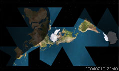
The favourite radiomap image. But too confusing for participants. The perspective in unusual enough but the day and night live view is essential for the experience. Together it is too much.
Fuller's dymaxion map is a polyhedron that exists of 18 individual gnomonic projections and 4 additional partial, gnomonic projections. Two complex procedures make this version problematic. It would require to employ a “dymaxion coordinate system” and accurately translate the conventional geographic coordinate systems measurements of the familiar Latitudes and Longitudes to this projection method for every location used. The second difficulty is the night and day display of the photorealistic map of the world which is to be updated in five minute intervals. The day and night regions are rendered from two different map sources, an all-day and an all-night map. As there is no all-night map available with the Fuller projection in would require to create one. Moreover it would have to display man made lighting effects (city lights) determined by population size which are necessary for participants to properly orientate themselves and navigate the area of the earth which is currently not lit by the sun. Both requirements would have been tasks too ambitious to achieve within the framework of this research project on immersive telematics. The unfamiliar perspective of the Dymaxion Map also requires very good knowledge of the geography of the world and enhancing it with additional night layer would be a perspective too unfamiliar for most participants to facilitate controlled orientation and navigation. It would be a fantastic journey.
There is a dymaxion plugin for Hari Nair's xPlanet and on the BFI website the code for translating Lat/Long to dymaxion coordinates has become available.
go back
|