Plateauinteractive VRML interface metaphor
My fifth semester i spend fiddling around with Cosmoworlds trying to find a metaphor for the city.scope image archive.
It's a bit confusing, because the very same image taken yesterday at 13:00 exists in four different formats: As a 360 degree image, a 180 degree image, a QTVR movie and the 16 original unstiched images.
The idea was to develop a 3D Interface Metaphor that would provide an overview over the complete content as well as an easy approach into the different archives. So the place of interaction, the interface, should be identical with the place the information was presented.
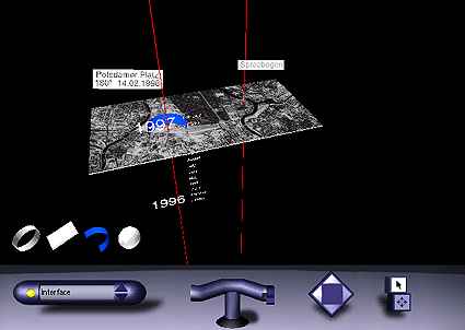
The four geometrical objects stand for the different archives. The Plateau is a map of the center of Berlin, and the two red lines mark the two camera locations: One at Potsdamer Platz, the other one at Spreebogen. They function as the timeline as well, comeing out of nowhere - and vanishing into nowhere. (The dark plane in the middle is the Tiergarten parc, the dark bow above the Spree river forming the Spreebogen.)
The Sliders are interactive, and the months are LODs, so they dissolve into the single days of the month, as you approach them. (LOD = Level of Detail)
When the harddisk of our historic Crimson crashed the data was lost and three month worth of work ... .
Or take a look at the real thing at: http://www.cityscope.de
|